|
 The Central West Coast of Ireland is our name for the area just south of Galway that includes The Burren, the Cliffs of Moher, and the Aran Islands. The common theme among them is ROCK. The Central West Coast of Ireland is our name for the area just south of Galway that includes The Burren, the Cliffs of Moher, and the Aran Islands. The common theme among them is ROCK.
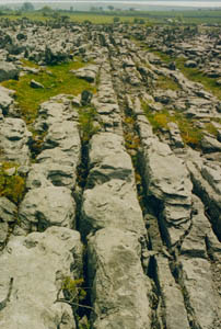
The Burren is a vast land area of almost pure rock; valleys, hills and plains alike. The Irish name is Boireann which means Rocky Country. It is really quite awesome but very beautiful. We visited The Burrren in early spring, 1999 with Verna’s folks. At right is a photo of what the gr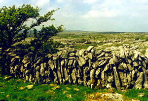 ound looks like. Yes, there is some soil, but precious little. You can see some pastures in the background, but they are the exception, not the norm. At left is one of the many rock walls made to separate the pastures and contain the animals. Obviously those who settled here had a lot of raw material at their disposal. But a flock of sheep would have to have a very large area to get enough food to eat. ound looks like. Yes, there is some soil, but precious little. You can see some pastures in the background, but they are the exception, not the norm. At left is one of the many rock walls made to separate the pastures and contain the animals. Obviously those who settled here had a lot of raw material at their disposal. But a flock of sheep would have to have a very large area to get enough food to eat.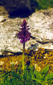
 n this area there are several rock tombs (left), presumably created by ancient people to lay their dead to rest. Given the size of the topmost rock, it took some ingenuity (as well as brute strength) to create this structure so long ago. There are tombs like this to be found all over the Burren, as well as ring forts, round towers and Celtic high crosses. n this area there are several rock tombs (left), presumably created by ancient people to lay their dead to rest. Given the size of the topmost rock, it took some ingenuity (as well as brute strength) to create this structure so long ago. There are tombs like this to be found all over the Burren, as well as ring forts, round towers and Celtic high crosses.
But even with all the rock and inhospitable growing conditions, spring flowers (right) continue to bloom, showing new signs of life.
One of Cromwell’s generals is rumored to have called the Burren a place where there is “neither water enough to drown a man, nor a tree to hang him, nor soil enough to bury him.” Aptly stated. However, it is stunning in its starkness and a beautiful place to visit.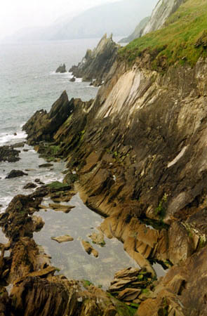
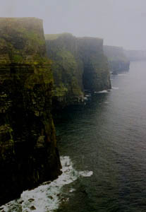 West and a bit south of the Burren, on the coast are the amazing Cliffs of Moher. They rise 203 meters (about 660 feet) from the ocean and are one of Ireland’s most famous natural features. The photo at left was taken with a bit of the sea mist in the air, yet the cliffs are clear enough to appreciate their massiveness. Looking south, these cliffs continue for several kilometers down the coast. West and a bit south of the Burren, on the coast are the amazing Cliffs of Moher. They rise 203 meters (about 660 feet) from the ocean and are one of Ireland’s most famous natural features. The photo at left was taken with a bit of the sea mist in the air, yet the cliffs are clear enough to appreciate their massiveness. Looking south, these cliffs continue for several kilometers down the coast.
In standard European fashion, you can walk right up to the edge of the cliffs without a guard rail or fence (those of us from the States are not used to this freedom). Verna laid on her stomach looking over the edge to get the photo at right, basically looking straight down, but to the rocky cliffs to the north. The entire area along this coast is quite dramatic and beautiful.
 |
In September of 2002, we returned to the general area to visit the Aran Islands which lie just off the coast of Burren. We only visited Inishmore, the largest of the chain and were quite impressed with what we saw. Above is a photo of the island, looking east from the Dun Aengus fort. Quite an inhospitable looking place, is it not? But actually, the islands were settled at a much earlier date than the mainland, as the heavily forested mainland was much more difficult to clear for agriculture.
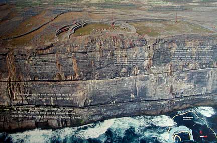 At left is an aerial view of the fort (compliments of the visitors’ center) that shows how the fort was perched right on the edge of the cliffs. The fort is surrounded by huge stone walls for protection from the land and the cliffs obviously serve protection from the sea. The fort was first enclosed around 1100 BC and the most dynamic period in its history was around 800 BC when it appeared to be the political, economic and ritual center for the people on the islands. There appeared to be a general decline in activity of the fort from 700-500 BC and very little evidence has been found for the era from 500 BC to 500AD. Then in the period from 500 to 1000 AD, much remodeling of the walls and fortress were done and there were indications that a small residential area was included in the area. At left is an aerial view of the fort (compliments of the visitors’ center) that shows how the fort was perched right on the edge of the cliffs. The fort is surrounded by huge stone walls for protection from the land and the cliffs obviously serve protection from the sea. The fort was first enclosed around 1100 BC and the most dynamic period in its history was around 800 BC when it appeared to be the political, economic and ritual center for the people on the islands. There appeared to be a general decline in activity of the fort from 700-500 BC and very little evidence has been found for the era from 500 BC to 500AD. Then in the period from 500 to 1000 AD, much remodeling of the walls and fortress were done and there were indications that a small residential area was included in the area.
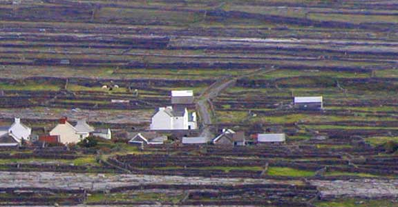 At right is a small community amongst the rock walls and patches of rocky earth. At one point, we expect that the entire island looked like the rocky patches, before the fields and walls were created. The soil was made by the settlers by bringing in seaweed and sand to the newly cleared areas. Potatoes were then planted to provide food for the settlers. The next year rye was planted to provide grain and straw for the thatch roofs. The third year other crops could be planted as the soil was now well prepared. It was a tough life on the island and over the years population has gradually declined to several hundred residents. At right is a small community amongst the rock walls and patches of rocky earth. At one point, we expect that the entire island looked like the rocky patches, before the fields and walls were created. The soil was made by the settlers by bringing in seaweed and sand to the newly cleared areas. Potatoes were then planted to provide food for the settlers. The next year rye was planted to provide grain and straw for the thatch roofs. The third year other crops could be planted as the soil was now well prepared. It was a tough life on the island and over the years population has gradually declined to several hundred residents.
|

 The Central West Coast of Ireland is our name for the area just south of Galway that includes The Burren, the Cliffs of Moher, and the Aran Islands. The common theme among them is ROCK.
  ound looks like. Yes, there is some soil, but precious little. You can see some pastures in the background, but they are the exception, not the norm. At left is one of the many rock walls made to separate the pastures and contain the animals. Obviously those who settled here had a lot of raw material at their disposal. But a flock of sheep would have to have a very large area to get enough food to eat.

 West and a bit south of the Burren, on the coast are the amazing Cliffs of Moher. They rise 203 meters (about 660 feet) from the ocean and are one of Ireland’s most famous natural features. The photo at left was taken with a bit of the sea mist in the air, yet the cliffs are clear enough to appreciate their massiveness. Looking south, these cliffs continue for several kilometers down the coast.
 At left is an aerial view of the fort (compliments of the visitors’ center) that shows how the fort was perched right on the edge of the cliffs. The fort is surrounded by huge stone walls for protection from the land and the cliffs obviously serve protection from the sea. The fort was first enclosed around 1100 BC and the most dynamic period in its history was around 800 BC when it appeared to be the political, economic and ritual center for the people on the islands. There appeared to be a general decline in activity of the fort from 700-500 BC and very little evidence has been found for the era from 500 BC to 500AD. Then in the period from 500 to 1000 AD, much remodeling of the walls and fortress were done and there were indications that a small residential area was included in the area.
 At right is a small community amongst the rock walls and patches of rocky earth. At one point, we expect that the entire island looked like the rocky patches, before the fields and walls were created. The soil was made by the settlers by bringing in seaweed and sand to the newly cleared areas. Potatoes were then planted to provide food for the settlers. The next year rye was planted to provide grain and straw for the thatch roofs. The third year other crops could be planted as the soil was now well prepared. It was a tough life on the island and over the years population has gradually declined to several hundred residents.